Site Surveys and Path Loss for Microwave Paths in the Turtle Mountain Reservation
Summary...
Achieving a 45Mb/s ring using the Western Multiplex Tsunami radios
around Turtle Mountain can be done. Four sites have been identified
to cover the reservation; The new Turtle Mountain Community College
(TMCC) building, the KEYA FM
tower, the tower in Shell Valley and the tower owned by Shindler
cable TV. One to two towers will need to be erected to either
replace current towers or to gain height for paths. Paths are
relatively short 3 or 4 foot dishes will be needed for a sufficient
fade margin. As the paths are short, uptime due to climate should
be high.
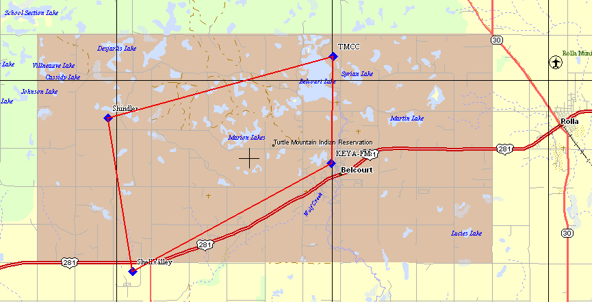
The New TMCC to KEYA-FM
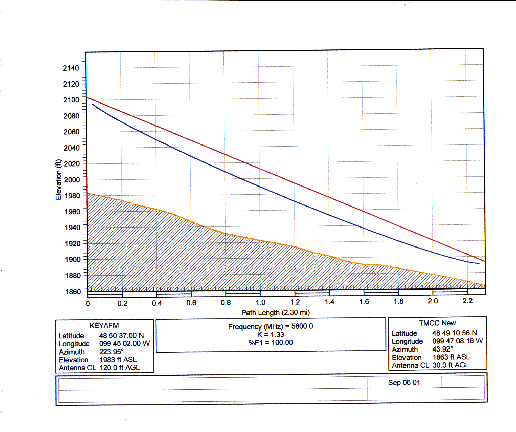
The path...
The first link of this path is a pretty clean shot. It assumes
that an antenna be place about 30 feet above ground level (AGL)
(such as the TMCC roof) at the TMCC. The other end of the link's
antenna is shown here at 120 AGL. It could even be dropped down
to the 70 foot level and still clear the ground and first fresnel
zone. At this point it likely will run into vegetation such as
trees.
Path Calculations...
This path can use 2' dishes with a 6.9dB of fade margin. This is
a bit tight. Upgrading to 3' dishes will add 3.7dB on each end.
Path assumptions and performance calculations can be found here.
Technical needs...
At the new TMCC and assuming that this would be a roof mount, a
tower or pole would needed in close proximity to a penetration
point where the the coax for both paths (Shindler and KEYA-FM) can
be brought down to the base band electronics. This will determine
the coax length needed for the path calculations. At this point
I am assuming 100'.
At the KEYA-FM site we need access to the current tower to hang
two antennas (New TMCC and Shell Valley). As discussed below, we
may have a problem with the KEYA-FM to Shell valley path and would
need that antenna to be at 120' AGL or above. The "racked"
electronics of the Tsunami radios would be co-located in the
transmitter shack of KEYA-FM.
KEYA-FM to the Shell Valley Tower
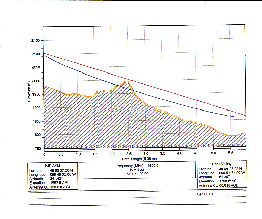
The path...
This path may have a "knife edge" problem as it looks like there
is a hill about 2.5 miles out of KEYA-FM. With the current AGL
assumptions of 120' AGL at KEYA-FM and 67 feed for Shell Valley
this path cuts into the first fresnel radius by 40 feet. The path
should be raised by this amount such as 160 feet at KEYA and 100
feet AGL on the Shell Valley tower.
Path Calculations...
This path can use 3' dishes with a 6 dB of fade margin. Predicted
up time would be 99.980516% or 102.41 minutes a year. If we can
get away with it on the KEYA tower, I would suggest 4' dishes on
each end which gets us 5.2 dB more margin (11.2 dB). This will
give us a predicted 99.994116% uptime or 30.39 minutes per year
outage.
Path assumptions and performance calculations can be found here.
Technical needs...
KEYA-FM site was discussed above.
Shell Valley's tower ([IMAGE1]
[IMAGE2]) is at best marginal.
It has been long abandoned and as such not maintained. A structural
engineer should look at the facility to see if the tower will handle
the wind load and what additional maintenance is needed before
installation.
Power is currently not plumbed into the base of the tower. There
is power supplied about 100 to 200 meters away at another building.
A minimal amount of power would be needed for this site as the
Western Multiplex Tsunami radios take less than 1 amp at 115VAC.
Figuring the addition of a router and down-link radios a 20 amp
circuit would be fine.
A "dog house" or "radio shack" would be needed for this site as
there currently isn't one. Each Tsunami radio takes 2 RU of rack
space and are about 15 inches deep. With the addition of a router
and other equipment for this project a 2 or 3 foot rack would be
sufficient.
In order to address the possible attenuation on this path due to
a hill cutting into the first fresnel zone we may need to add some
tower height to the Shell Valley tower. We can install first and
see if the path works with this obstruction.
Non-Technical Note: There is a question if Shell Valley is
on the reservation. The tower location is outside of the boundaries
of the reservation according to Yahoo Maps, Delorme Street Atlas
USA, etc.
Shell Valley Tower to the Shindler Tower
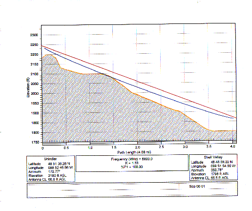
The path...
This path is a pretty clear shot with only a slight intrusion into
the first fresnel zone about 1.4 miles from Shindler. AGL is
assumed to be 66 feet for Shindler and 66 feet for Shell Valley.
Path Calculations...
This path can use 2' dishes with 8.9 dB of fade margin. Uptime
would be predicted at 99.996842% or 16.6 minutes a year outage.
Increasing to 3 foot dishes would get a path that has 16.3 dB of
fade margin or 99.999425% uptime (3.02 minutes a year outage).here.
Technical needs...
The Shindler tower ([IMAGE1]
[IMAGE2]) is well maintained and
has everything one would want. We just need to arrange to get
about 3 feet of rack space, power and room for the antennas on the
tower.
Shindler Tower to the New TMCC
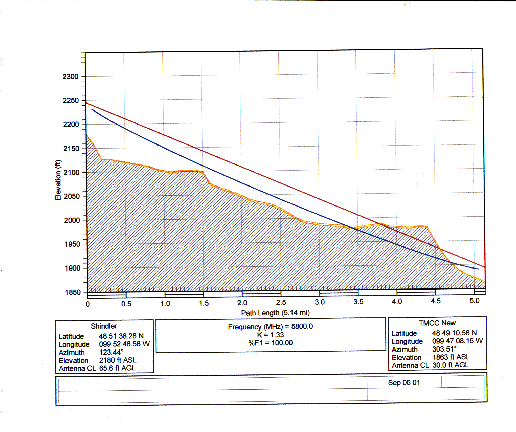
The path...
With the assumptions of 66' AGL on the Shindler tower and 30' on
the roof of the new TMCC building this path will not work unless
we can gain at least 50' feet of antenna height from the assumptions
on each end. This would require at least a 100' tower at the new
TMCC site. I am assuming we could get 116' AGL on the Shindler
tower.
Path Calculations...
Assuming we have a clear shot with the AGL needed on both ends,
with 3' dishes we would have a fade margin of 14.3dB and an uptime
of 99.998176% or outages totaling 9.59 minutes a year.
Path assumptions and performance calculations can be found here.
Technical needs...
In order to make this path we need at least a 100' tower at the
new TMCC and need to get available tower locations from Shindler
to see if we can get 116' AGL to make this path.
Version:
$Id: pathloss_report.html,v 1.14 2001/09/25 21:06:11 pozar Exp $


